MBIU

The Mobile Bridge Inspection Unit (referred as MBIU) is an Articulated Structure mounted on a vehicle (a truck) as an aid towards proper inspection of bridges or similar infrastructures by enabling an inspection team of 3-4 persons carrying instruments access to the underside of bridge decks over flowing rivers or gorges, ROBs and flyovers and grade separated structures
The extensive working range of MBIU offered by Almondz above road / rail /water body level enables work to be carried out on high cable poles and special bridge constructions
All movements of the unit can be controlled very accurately and proportionally from the workman basket by a radio remote control. The especially designed boom systems result in lowest transporting dimensions and allow the unit to be operational within a few minutes
TECHNICAL SPECIFICATIONS
- Length of boom no. 1=4.15m
- Boom no. 2 with three hydraulic extension booms
- Boom 3 with three hydraulic extension booms
- Automatically leveled basket at the end of boom no. 3
- Outside dimensions of basket 1.0 m (width) x 0.8 m (length)
- Maximum payload 280 kg consisting of persons andTools
- Maximum working height approx. 23.5 m above road / rail level
- Maximum horizontal reach underneath bridge deck approx. 11m
- Maximum working depth below road / rail level approx. 14.5m
- Manual control at main rotating column
- Radio remote control in workman basket
ACTIVITIES WHICH CAN PERFORMED BY USING AGICL'S MBIU
- Physical inspection of underside of bridge structures during flowing conditions to assessthe distress condition of various components
- Cleaning of all bushes, jungles, small tress and their roots etc
- Inspection and Cleaning of drainage spouts, expansion joints, bearings, pedestals etc
- Greasing to the bearings
- Carrying out required tests on the structure such as NDT, Core cutting method etc. as per the Guidelines specified various codes
ADVANTAGES OF HIRING MBIU OFFERED BY ALMONDZ
- Using AGICL's MBIU, it will help to collect inventory data, preparing analysis of bridge condition and assessment of distress condition, preparing estimate for remedial measures wherever necessary with the corresponding methods and technique for repair and rehabilitation of the Bridges, Flyovers and ROBs, which in turns help the Client to prepare the budget more efficiently and will save life, time and money
- Using AGICL's MBIU will improve operational availability of the structure
- Using AGICL's MBIU will prevent downtime and enhance the life of the structure
- Using AGICL's MBIU will avoid the accumulation of defects, which manifest in the form of major defects at a later date, rendering the asset unserviceable for prolonged duration
- Using AGICL's MBIU will help to prepare database to enable the Authority to detect the proper timing for carrying out maintenance
- Using AGICL's MBIU will consolidate requirements of periodical maintenance through suitable agencies/ offloading
NSV
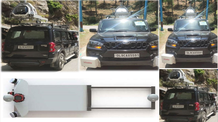
The Network Survey Vehicle is based on the latest survey techniques utilizing Laser, Global Positioning System and Video image processing tools etc. The Survey Vehicle is used for automatic collection of road inventory and pavement condition related data required for Road Asset Management, Pavement Maintenance Management System and Road Safety Audit Related Studies
In line with its commitment to provide better roads to commuters, NHAI and other State Government agencies in India and Overseas has decided to deploy Network Survey Vehicle (NSV) to enhance quality of the national highways. Carrying out road condition survey using NSV has been made mandatory at the time of certifying completion of the project and every six months thereafter.( Or as per Client Requirement)
TECHNICAL SPECIFICATIONS
- LiDAR sensors - Velodyne VLP 16 - 2No.
- Trimble Applanix POS LV 125
- Ladybug 5+ FLIR
- Distance Measuring Instrument
- Mounting Kit
- ViaPPS Software Suit
- Data Collection Computers/Laptops and Other accessories are equipped in unit
NSV SPECIFICATION
- Latest Product in scanning and Mapping Technology from ViaTech
- Light and Compact design
- Flexible frame - can be installed/removed from a vehicle easily
- Easy Transport - Entire assembly can be carried in a transport case
- Design Flexibility - Easy system upgrade, the addition of high-resolution cameras, higher GNSS system, multiple LiDAR etc
- Data Compatibility - Export into. las/. laz and another 3D point cloud compatible format
- Enhanced remote support capabilities
- Export to Orbit GT
- Suitable for Corridor and Utility Mapping
ACTIVITIES WHICH CAN PERFORMED BY USING AGICL'S NSV
- Almondz Network Survey Vehicle (NSV) mounted with equipment such as Laser based automatic crack detection, high resolution digital cameras for RoW and surface pavement defects, high accuracy DGPS receiver and in vehicle data processing software to accurately measure pavement surface properties such as cracking, potholes,
- Longitudinal and transversal profile
- Rut depth, rut area and rut area volume
- Crossfall & Crossfall Requirement, curve radius
- Longitudinal deflection/Bumps
- IRI and MPD
- Width of the lane Bad joints of the asphalt / Concrete
- Crack parameters
- Tunnel/Bridge profile including height
- 3D data to external standard format such as xyzi, las/laz
- WEB interface and 360 photo integration
ADVANTAGES OF HIRING NSV OFFERED BY ALMONDZ
- The deployment of Almondz NSV will help in enhancing the overall quality of the highways as NSV uses the latest survey techniques such as high-resolution digital camera for 3600 imagery, Record images/videos at regular intervals, Laser Road Profilometer and other related technology for measurement of distresses in road surface
- Almondz NSV will also help to collate data to analyse the road condition including measurement of the road surface, surface cracking, potholes and patches. Apart from this, NSV will also provide data insights relating to side drains, road furniture, etc
- The data will help in maintaining up to date asset inventory and road assets condition status. Apart from delivering vital information on road network planning, providing relevant information on other aspects such as development of road safety measures, etc. it will also assist in developing highway maintenance strategies, analysis of maintenance and selection of optimal maintenance regime
- The data collected through NSV surveys will highlight deficiencies in road conditions, prompting BOT operators/Govt officials to take corrective steps to bring the road condition to the desired level. This will further result in better upkeep of national highways, leading to more comfort and better travel experience for highways users
- Key Benefit : Via 3D Mapper is a cost-effective solution that can be widely used in corridor mapping for utilities, municipalities and town planning for assets mapping 3D modelling of existing infrastructure
FWD
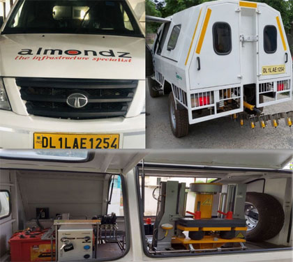
Structural evaluation of pavements involves application of a standard load to the pavement and measuring its response in terms of stress, strain or deflection
Falling Weight Deflectometer has become popular all over the world for evaluate the physical properties of pavement in highways, local roads, airport, harbor areas, railway tracks etc
The FWD data can also be very useful in helping the engineer divide the length of the pavement into homogeneous sections and also to calculate the degree of load transfer between adjacent concrete slabs, and to detect voids under slabs
ADVANTAGES OF HIRING OFFERED BY ALMONDZ
The equipment offered by Almondz is smart and fully automatic system built around intelligent microcontroller based system which, acquire data and process data on high speed with high accuracy and reliability. The control system is fully automatic and controlled by processor
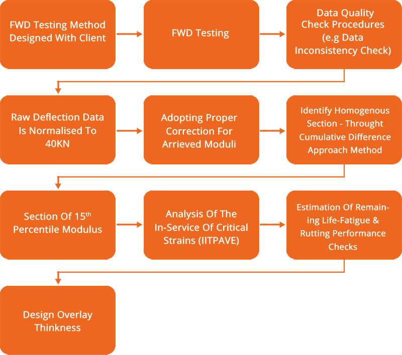
Working of FWD
During testing, a FWD subjects the pavement surface to a load pulse which simulates the load produced by a rolling vehicle wheel. The load pulse is produced by dropping a large weight onto a "buffer" which shapes the pulse, and then transmitted to the pavement through a circular load plate. Data are acquired from various sensors for use in post-test analysis of pavement properties.
Sequence of FWD data analysis
Technical Specification of AGICL FWD
| Make and Model |
Model No: GTFWD V
Make : Geotran , Roorkee
Mounted on TATA Yodha 1700 |
| Operation |
Fully Automatic. All operation through Laptop/Tab |
| Impact Load |
75 kN (Max.)
Load Resolution: 0.01 kN |
| Load Sensor |
100 kN |
| Loading Impact Plate |
300mm diameter and 31 mm thick with reinforced checkered rubber (solid/segmented) |
| Impact Height |
4 to 40 Cm (Software adjustable) |
| Impact Weight |
Min 100 kg (as Standard), max 400 kg (add weight 25 kg to each side) plate along with a universal hinge at the upper part of plate to ensure that the loading plate align itself as per the camber of the road |
| GPS and Distance Measuring Unit |
Integrated GPS (Latitude, Longitude and Altitude) and distance measuring unit |
| Geophone |
7nos. (for deflection measurement)
Deflection Resolution: 0.001mm (1 micron) |
| Temperature Sensor |
2 nos. One each for air & road surface temperature |
| Data Acquisition |
Laptop with High speed Data Acquisition System, acquire data of geophones, load, temperature and GPS etc |
| Software |
GEOTRAN FWD Analysis software
Easy operation.
Graphical presentation of captured data of geophones, load cell. |
| Operating System |
Window XP/7/8/10 |
| Back Calculation |
KGP back 4-layer and 3-layer/ BAFAA |
| Supply |
48 Volt Battery, chargeable from AC mains (external source) |
| Power backup |
6 to 7 hours continues operation with one full charge of battery |
ATCC

ATCC is an electronic device camera and sensors to count system that uses the exact number of two-wheelers, four-wheelers and commercial or heavy vehicles passing through the section and to conduct traffic surveys using on sections of Highways throughout the country
To standardize the process of data collection and creating of central data repository, MoRTH (Govt. of India) envisaged to conducting traffic surveys on National Highways using Portable Automatic Traffic Counter and Classifier (ATCC) Systems
ATCC offered by Almondz is capable of counting vehicles according to their class with help of different non-intrusive technologies such as video / photographic method based, infrared sensors, Pneumatic tubes etc
The video cameras for recording work with IR flash capable to capture videos during the night so that this video could also be used for visual comparison with the ATCC data
Technical Specification of AGICL ATCC
- Model Number - KVC02
- Maxwell architecture with 128 NVIDIA CUDA core
- 0.5 TFLOPs (FP16) CPU Quad-core ARMCortex-A57 MPCore processor
- Memory4 GB 64-bit LPDDR4 1600MHz - 25.6 GB/sStorage16 GB e MMC 5.1 Flash
- Video Encode 250 MP/sec 1x 4K @ 30 (HEVC) 2x 1080p@ 60 (HEVC) 4x 1080p @ 30 (HEVC)
- Power Consumption 5V 4A, 60 Watt
- Runs offline, Don't need internet
FEATURES OF KVCO2 MODEL OFFERED BY ALMONDZ
- Runs without internet
- Portable, can be installed any where
- Can run with power bank just take 5V 4A, which is 60 watt
- Can be connected to HDMI monitor
- Can be access via mobile phone /pc
- High Speed GPU Process Video and Imagesfaster than any other regular computer
RETROREFLECTOMETER
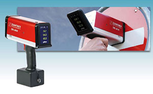
- Ergonomic retroreflectometer for determination of night visibility (coefficient of retroreflection RA and R') of traffic signs, safety garments and other reflective materials with measurement of three different observation angles at the same time
- The very first retroreflectometer with LED illumi-nation system and with a 3.5' high resolution colour touchscreen with adjustable display inclination for excellent visibility under all light conditions also in bright sunlight
- Innovative options to customize the reflectometer to personal requirements: integrated 5- megapixel camera, WAAS GPS-unit, holster, handles and many more
- For all kinds of retroreflective materials and colours with automatic colour indication
- Continuously updated average value; each single measurement is stored additionally
- Measurements can be evaluated with the included mapping and data analysis software 'Mapping Tools'
- Easy to operate with polyglot menu navigation
- Sturdy construction and ergonomic design
- Robuste Konstruktion und ergonomisches Design
Drone
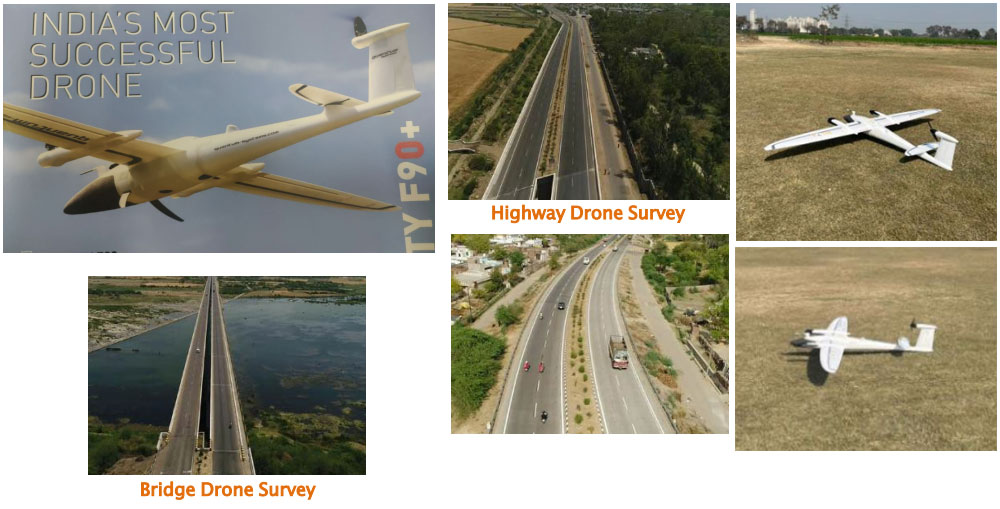
Drone Survey services to its customers with high data accuracy, quality control, process-oriented approach, quick turnaround time and single point solution to all of your needs We are currently offering the following solutions in drone sector: -
- GIS Survey
- LiDAR Survey
- Ortho photo Generation
- Cadastral Mapping Solutions
- DSM/DEM/DTM
- 3D Modeling
- 3D Point cloud generation
- Contour Maps
- Cut-fill volume analysis
- Agricultural solutions for corporate farms
- Volumetric Analysis
| S. No |
Particulars |
Remarks |
| 1 |
Type of RPA/ Drone |
Fixed Wing |
| 2 |
Max take-off weight of RPA (including Payload) in KGS |
5 |
| 3 |
Category of RPA/ Drone |
Small |
| 4 |
Drone Manufacturing Number |
00735i |
| 5 |
Drone Acknowledgement Number (DAN) |
D1DA00VSU |
| 6 |
Unique Identification Number (UIN) (If available) |
UA000ZZS0EN |
| 7 |
Type of Operations Undertaken |
Land Surveying |
| 8 |
Used In DAY time / NIGHT time |
Day |
| 9 |
Visual line of sight operation |
Yes |
| 10 |
Year of Manufacturing |
2023 |
| 11 |
Battery Life per charge of RPA (in Hours) |
90 Minutes |
| 12 |
RPAS Take-off Features |
EVTOL |
| 13 |
GPS Enabled |
Yes |
| 14 |
RPA Recovery/Landing Features |
Yes |
| 15 |
Anti-Collision System Enabled |
Yes |
| 16 |
Pilot Total Flying Experience (in Hours) |
2000+ |
| 17 |
Drone Constructed of |
1200 |
| 18 |
Geographical Conditions |
Carbon fibre and Elapore |